A travel app for road trips by car across Europe — web and Android.

SeekBone is your companion for a road trip by car across Europe — from a weekend in Croatia to a two-month expedition to Sicily. It plans your route, guides you through every day behind the wheel, keeps an eye on your money and the tolls, helps when things go wrong, and saves your memories. What would otherwise take five different apps plus paper notes is here in one place. It works offline and your data stays only on your phone: no ads, no data selling, no mandatory accounts.

Note: the app interface is primarily in Czech; a full English version is on the way.

No install needed: open the web version.
Coming soon to Google Play; App Store planned.

22
countries with data
15 000+
verified places
daily
data updates
7
interface languages
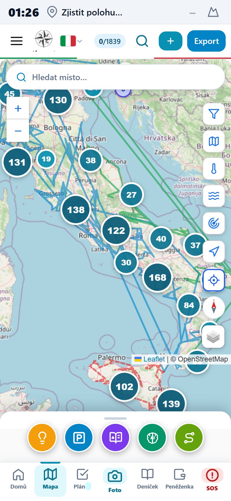
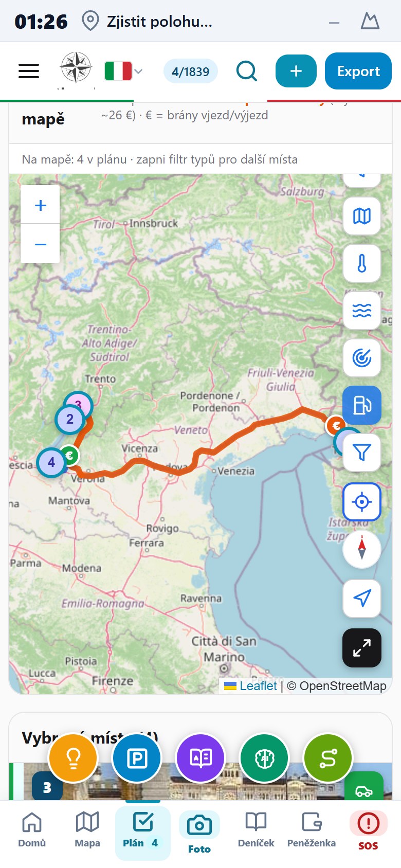
Map with thousands of places, a route and layers
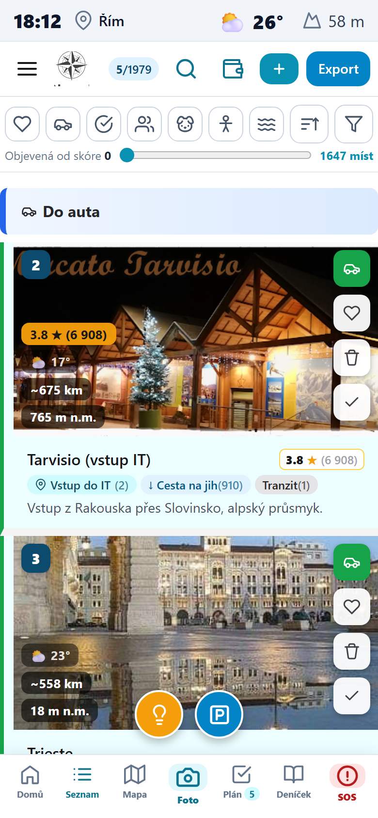
List of places with icon filters and the To car and Favourites groups
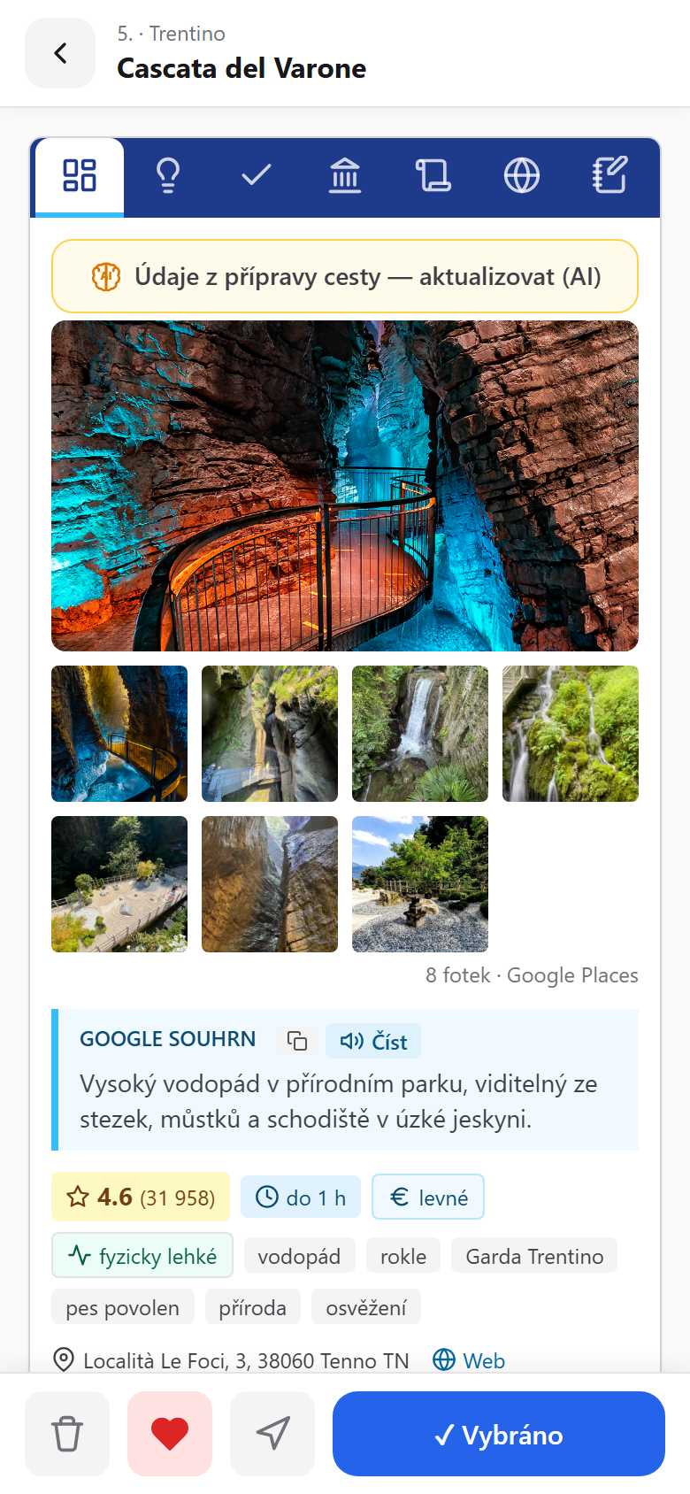
Place detail with Google photos and practical information

Share SeekBone with friends

The app is free. The more of us there are, the more accurate its information gets. Help us spread the word.

SeekBone in numbers22 countries, 15,000+ verified places — real data, not promises.

No promises — these are real numbers from the data already in the app.

22 countries, 15,000+ places

  • 22 countries with their own data: Italy, Austria, Greece, Croatia, Germany, Czechia, Slovakia, Poland, Hungary, Montenegro, Slovenia, Serbia, Albania, Bosnia and Herzegovina, North Macedonia, Bulgaria, Turkey, France, Spain, Portugal, Romania, Kosovo.
  • 15,849 verified places on the map — landmarks, beaches, towns, campsites, viewpoints, caves, waterfalls, hot springs.
  • Detailed country guides (emergency numbers, laws, tolls, sleeping in the car, customs limits) and colour region maps — plus a shared "Before you set off" guide for the whole route.
  • 8 countries with sea quality and temperature data; tolls from official 2026 rates, accurate to ±5%.
  • Daily data updates — the app grows practically every day, and we usually act on user suggestions within a day.

Largest countries: Italy 2 058 · Austria 1 874 · Greece 1 799 · Croatia 1 780 · Germany 1 752 · Czechia 1 233 · Slovakia 1 048 · Poland 764 · Hungary 714 · Montenegro 656 · Slovenia 577 · Serbia 569 · Albania 516 · Bosnia 191 places.

Italy — data depth (main destination)

Places in total2 058
Full cards (entry + parking + opening hours + peak times)693 · 34 %
Places with a description and practical info1 916 · 93 %
Google photos1 968 · 96 %
Kid-friendly places457
Places with nearby activity tips362

We keep adding full cards — the app grows practically every day, and at every place you see when it was last verified.

What only SeekBone does

Three things you won't find in an ordinary map or navigation app.

SOS system — rescue in one tap

How it helps: When something happens abroad and the language fails you, you have a ready message and medical details in one tap — and even a lost dog finds its way home.

SOS in one tap

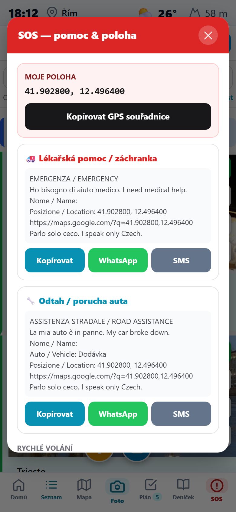
The permanent red button copies your GPS location and builds a ready-made message in the local language and English for emergency services or a tow.

Send it via WhatsApp or SMS, or quickly call 112, 118, 113 and 116.

SOS screen with GPS location and a ready-made message for emergency services and tow

A health card for everyone

Blood type, allergies, medication, diagnoses, insurance and emergency contacts — for every crew member and for the dog. A paramedic reads them from the QR even with no signal.

Sensitive fields stay with you — you publish only the ones you want. The sample below is empty.

Fill in your health card in the app →

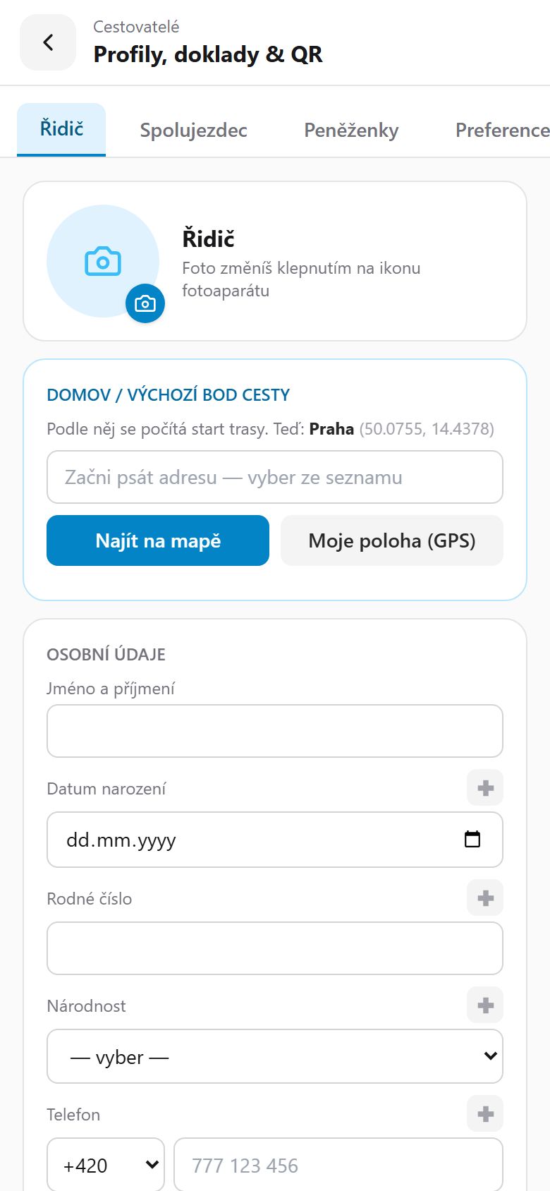
Empty traveller health card with profiles and personal details

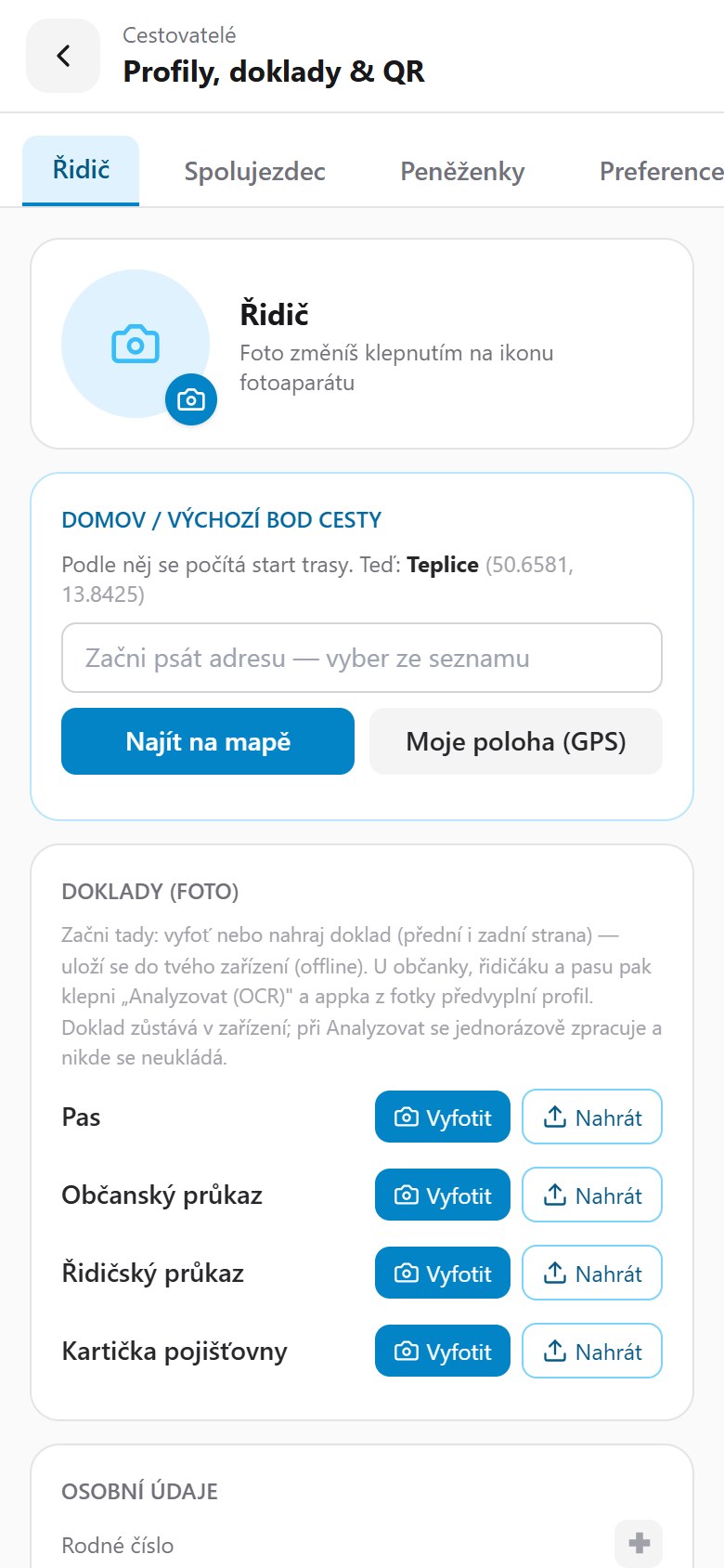
Documents in your phone — with photo capture (OCR)

Passport, ID card, driving licence and insurance card — photograph or upload them and they're saved only on your device, offline.

For an ID card and vehicle registration the app fills in the profile from the photo (OCR), understanding the machine-readable zone and the EU codes on the registration. The document is stored nowhere — it's processed once, on the phone.

Empty traveller profile with documents — passport, ID card, driving licence and insurance card, with OCR photo capture

A health card that understands medication

Open the health card in the app →

AI assistant and planning guide

How it helps: Instead of hours of googling, an experienced guide proposes a route, works out when to get up in the morning, and tells the story right there at the monument.

Say what you enjoy — the assistant suggests places

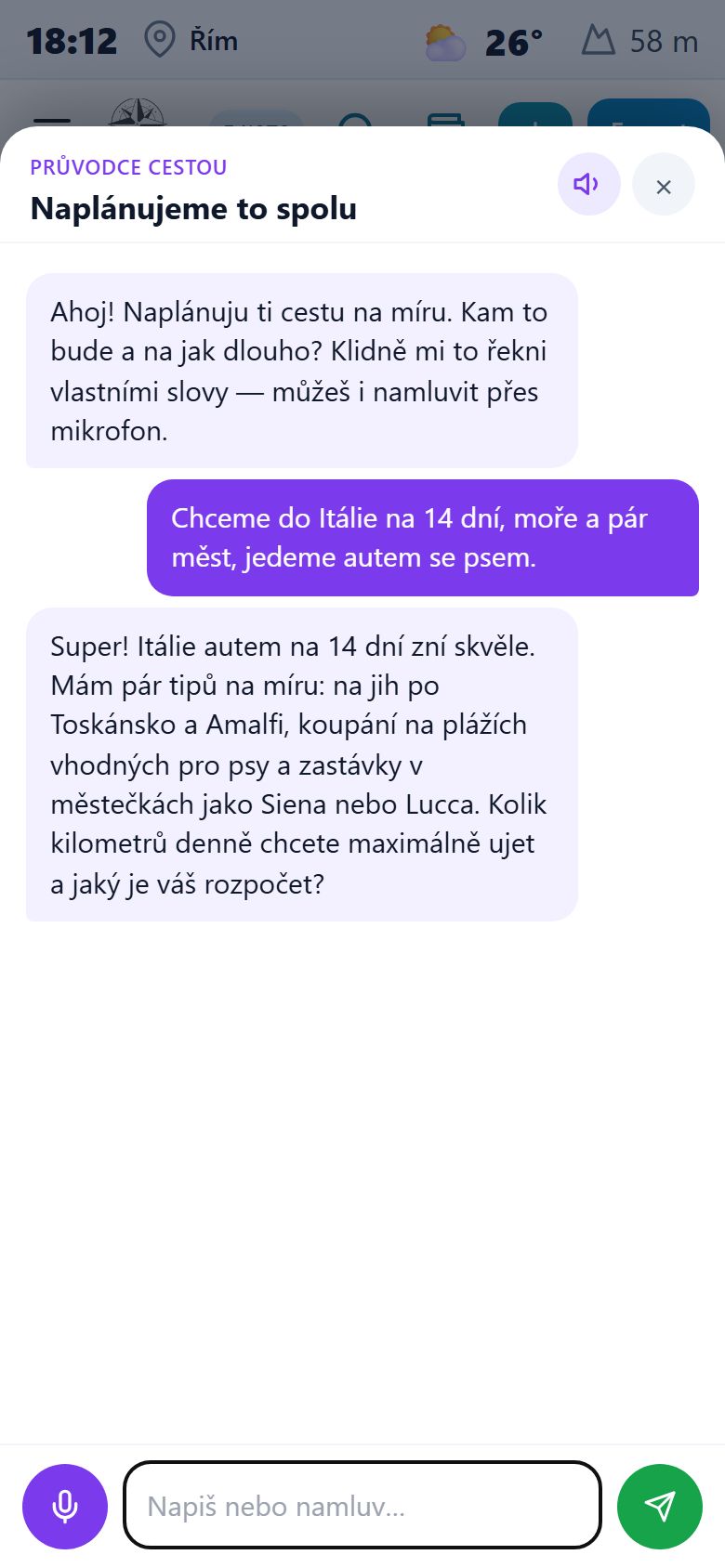
Type or speak where you want to go and what interests you. From the database the assistant picks places as cards you tap to build a route.

No digging through thousands of places — the guide understands plain language.

AI trip-planning assistant — a conversation about a route to Italy

Interactive app tour

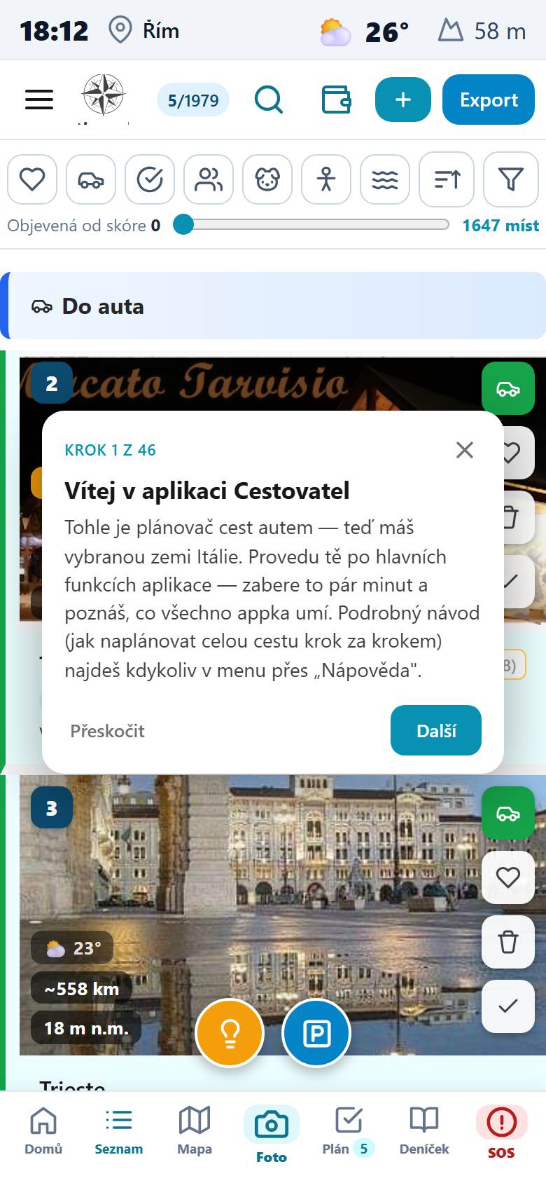
On first launch the app walks you through every feature step by step — it highlights the specific button and explains what it does.

46 steps from the list and map to the journal, route export and settings.

Interactive tour highlighting a button with an explanatory bubble
Trip planningRoute, tolls from official rates, vignettes and thousands of places on the map.

Route, tolls and the map

  • Thousands of verified places on the map. Tap the heart on what interests you and the app builds a route from it. Tap a colour region and you see only what lies within it.
  • A plan with real numbers. Distances, drive time (with traffic via Google, otherwise free via OSRM on real roads), fuel consumption and tolls — day by day.
  • Tolls calculated, not guessed. From operators' official 2026 rates, accurate to ±5% for every country and motorway. A taller car with a roof box pays double in some countries — the app accounts for vehicle height.
  • Tolls and gates on the map. Paid sections in orange, free in blue; gates marked (orange € = entry, green € = exit) with the motorway number and the section price.
  • Fuel stations with live prices right on your route. A layer of pumps along the whole journey with current prices at individual stations (Italy, France, Spain and more) plus regional averages — you see where to fill up cheapest. Filter by brand, service type (self-service vs. attended) and detour; a "On the route only" toggle keeps just the pumps directly along the way. The pump detail draws address, opening hours, phone, web, shop and car wash from OpenStreetMap.
  • Chargers and gas by drivetrain. EV chargers (operator, plug types, power in kW) and CNG / gas layers nearby; the relevant layer is offered at the top based on the vehicle in your profile. Data from OpenStreetMap, no keys needed.
  • Three Mapy.cz map backgrounds. Switch Basic / Hiking / Aerial — the hiking map has marked trails, terrain and Czech labels, the aerial one sharp satellite imagery of Europe. While you pan and zoom the map goes full-screen.
  • Round trip from places nearby. The app proposes a loop based on the time you have — by Car, on Foot or by Bike. Walking and cycling routes are computed along real trails and marked paths from Mapy.cz and drawn in their own colour (foot green, bike blue).
  • What's happening nearby. Culture, local customs and events in the area — the app sums them up so you know what's going on around you.
  • Stop-order optimisation. A "Sort optimally" button reorders stops so you drive the fewest kilometres; "Recalculate route order" recomputes after every change. The order survives a restart.
  • Navigation in Waze and Sygic. From a place detail or the plan you launch navigation to that stop in one tap (also Mapy.cz, Google Maps and GPX export).
  • 3D fly-around of a place. From the plan or detail you send a place to Google Earth, where the camera orbits the point (via a KML pin, with the coordinates copied to the clipboard).
  • Long-press a map marker. Quickly remove it from the plan (with undo) and switch the marker style — icon, number, or both.
  • Motorway stickers and vignettes. Enter validity and the app watches when it ends — including ones that don't cover the whole trip. The "Buy" link always leads to the country's official e-shop.
  • ZTL zones and vehicle height. Watches Italy's restricted-access zones and warns about underground car parks with a lower height limit.
  • Smart stop insertion. Add a place between two points by the smallest detour (green up to 15 km) — the route recalculates itself.
  • Trip checklist. What to sort before departure (disability card, Euro-key, vignettes, insurance, documents, dog…) — tick items off, add your own, see your progress.

How it helps: You know in advance how much the trip will cost, a toll gate won't surprise you on the motorway, and the app adapts whenever you change something.

Thousands of places with photos and ratings

Icon filters, the To car and Favourites groups, Google photos and ratings right on the card. Tap the heart to mark what interests you.

List of places with icon filters and the To car group

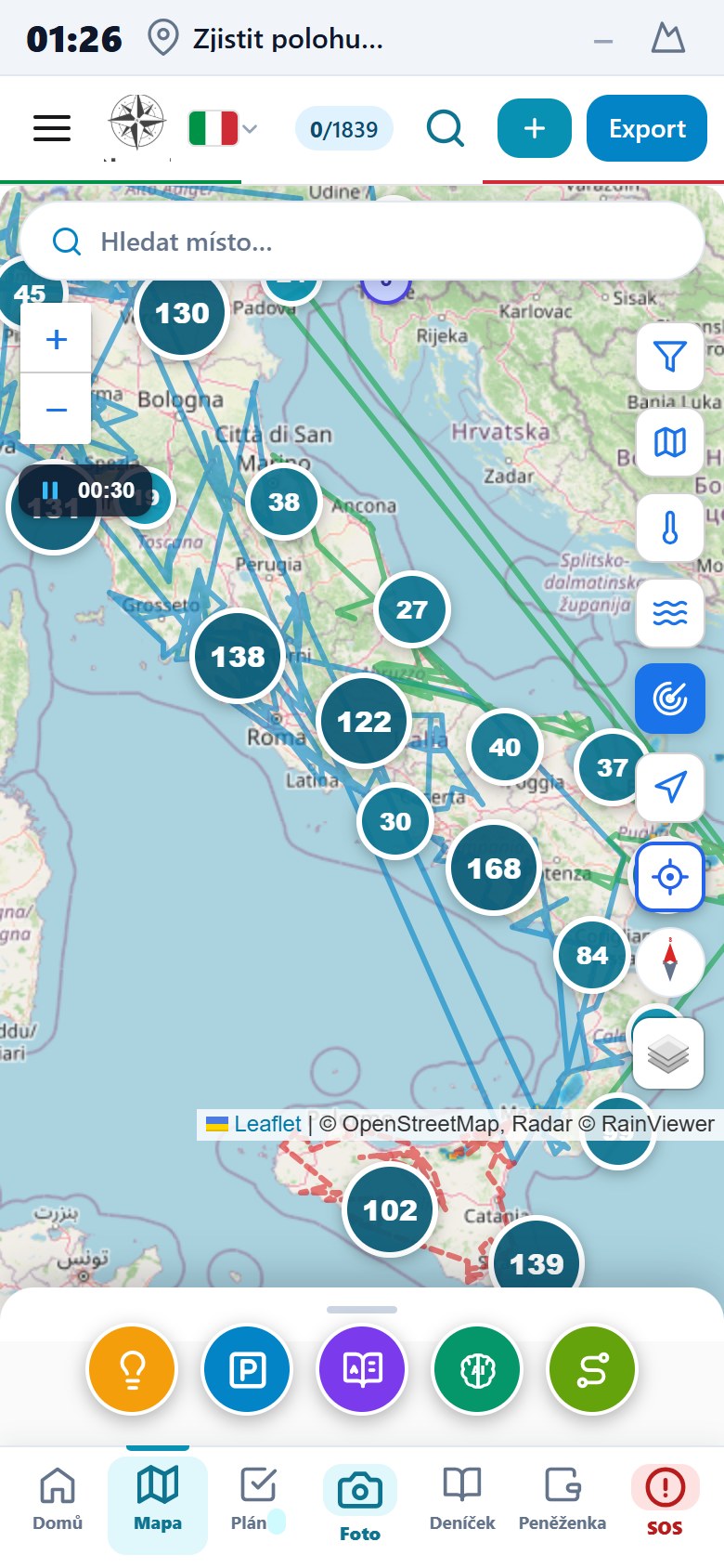
Your whole route on the map

Thousands of places in tidy clusters, colour layers (beaches, towns, nature) and the whole route in one view. Tap a region and you see only what lies within it.

Map with marker clusters, a route and layer switching

Pumps with live prices along the route

The planning map shows fuel stations along the whole journey with current prices at individual stations and regional averages — you know in advance where to fill up cheapest.

Plus toll gates, paid sections and a toll estimate for a taller car with a roof box.

Route planning map in Italy with a fuel-station layer, fuel prices and toll gates

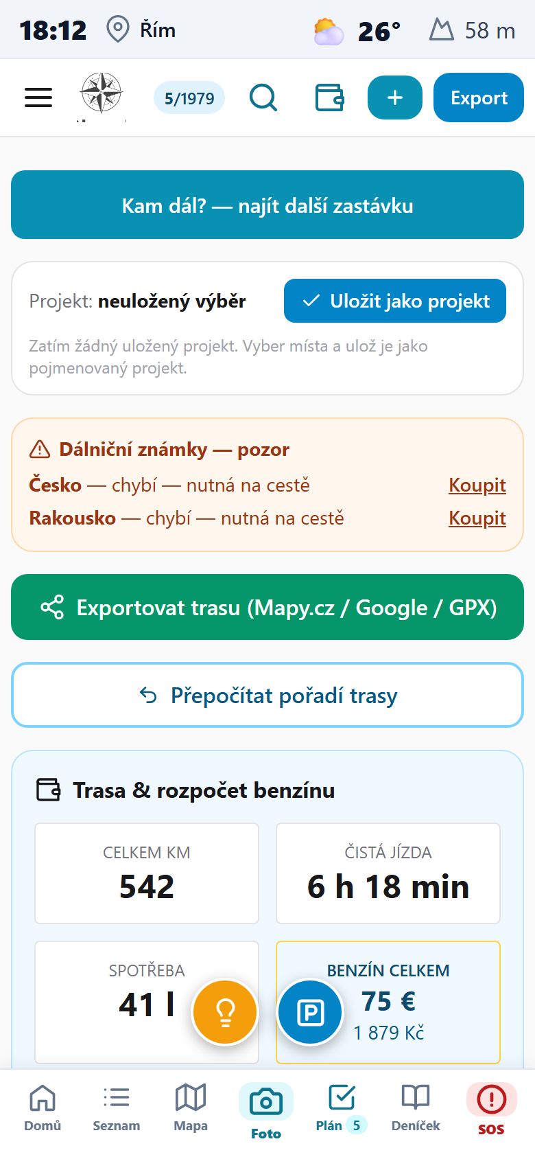
A plan with real numbers

Kilometres, net drive time, fuel consumption and fuel cost in euros and Czech crowns. A warning about missing motorway stickers with a link to the official e-shop.

Export the route to Mapy.cz, Google or GPX.

Route plan with kilometres, time, fuel consumption and cost in euros and crowns

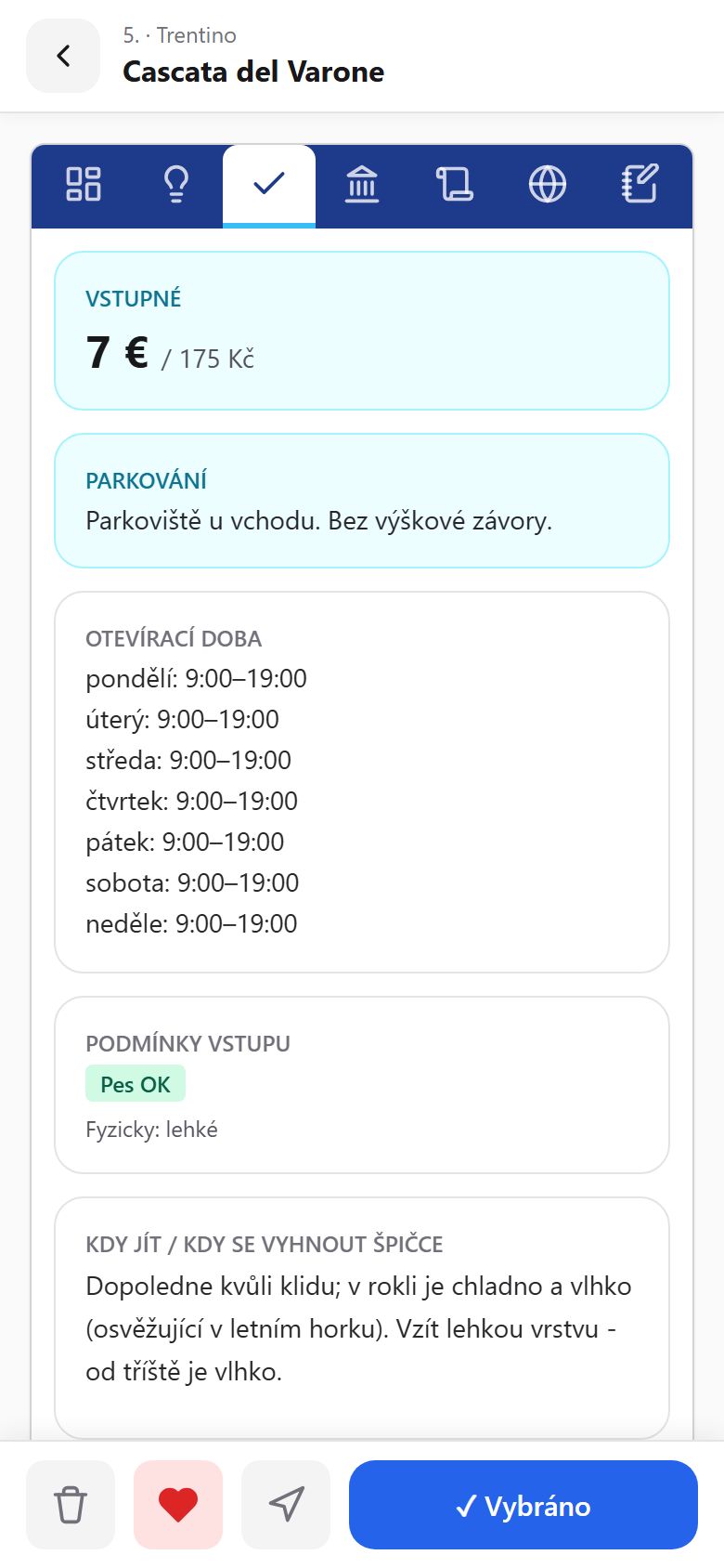
Practical data at every place

Entry fee, parking, opening hours day by day, dog rules, physical difficulty and when to avoid the peak — verified and current.

Practical place information — free entry, parking, opening hours, dog rules

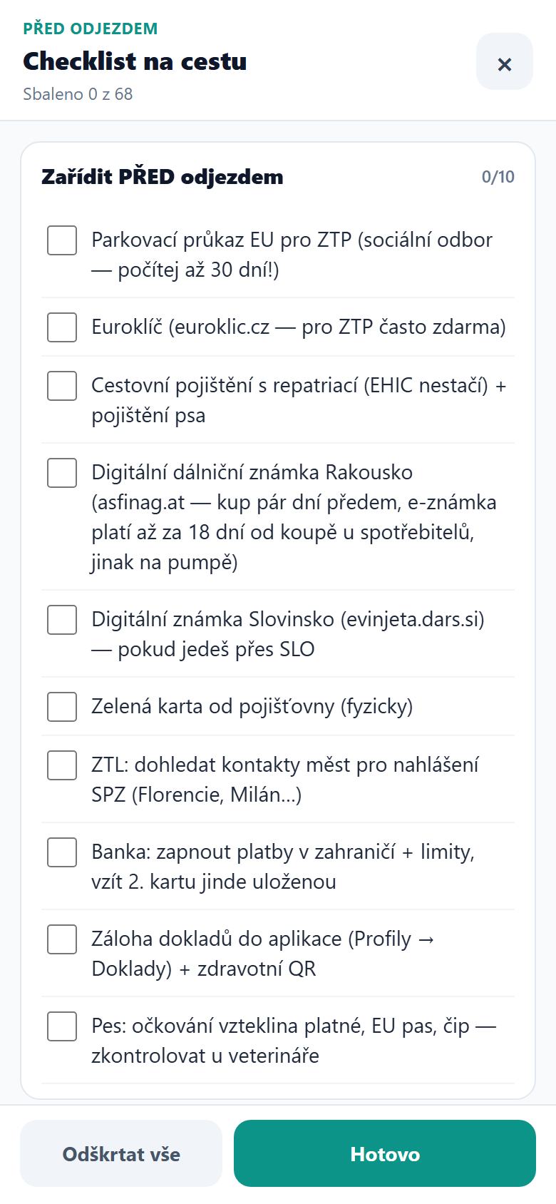
Trip checklist

What to sort before departure — vignettes, insurance, documents, Euro-key, the dog. Tick items off, add your own, and watch your progress.

Trip checklist with pre-departure tasks and tick-off progress
On the road every dayGPS track recording, parking with a countdown, wallet with charts, compass.

Recording, parking, wallet

  • Route recording (GPS track). It draws where you drove — on Android even with the screen off. It detects stops longer than 5 minutes: when, how long, the nearest place and photos from there. It can also compare plan vs. reality.
  • Parking with a countdown. Save where you're parked and until when it's paid; the app counts down, warns before the end, and on your return asks for the price and logs it in the wallet.
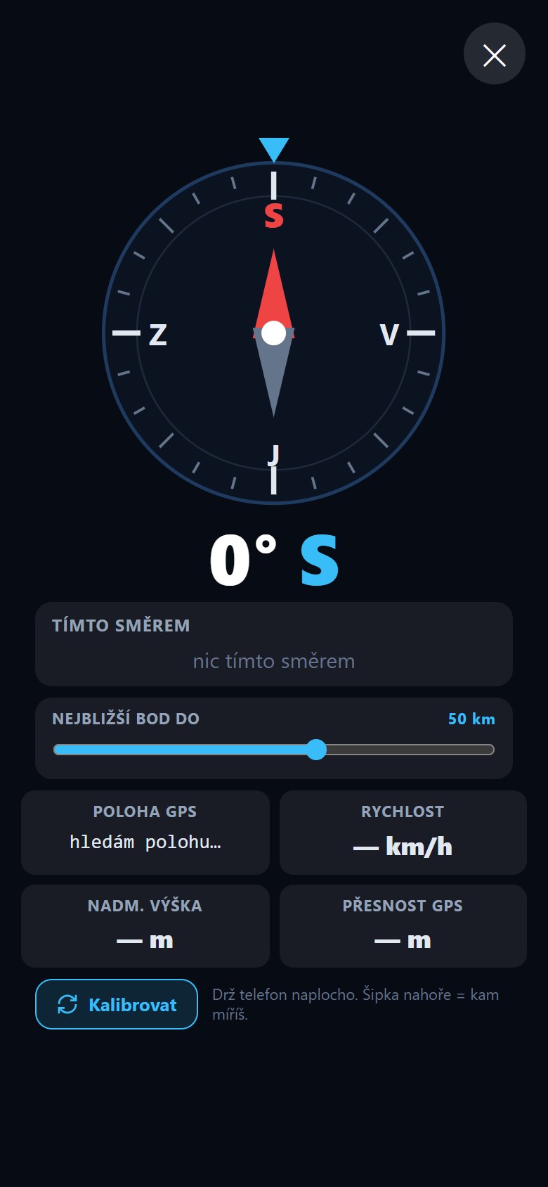
  • Compass, spirit level, altitude. The compass shows the nearest destination, a town within 50 km and a city within ~300 km in your direction of travel; the spirit level helps you level the car for sleeping.
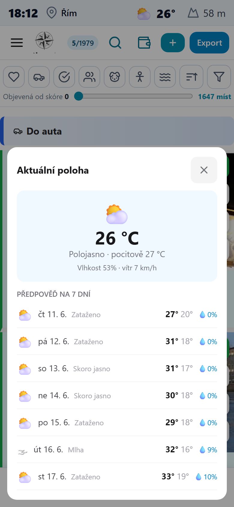
  • Weather and location always at hand. At the top: the time, weather and where you are; tap to expand a 7-day forecast.
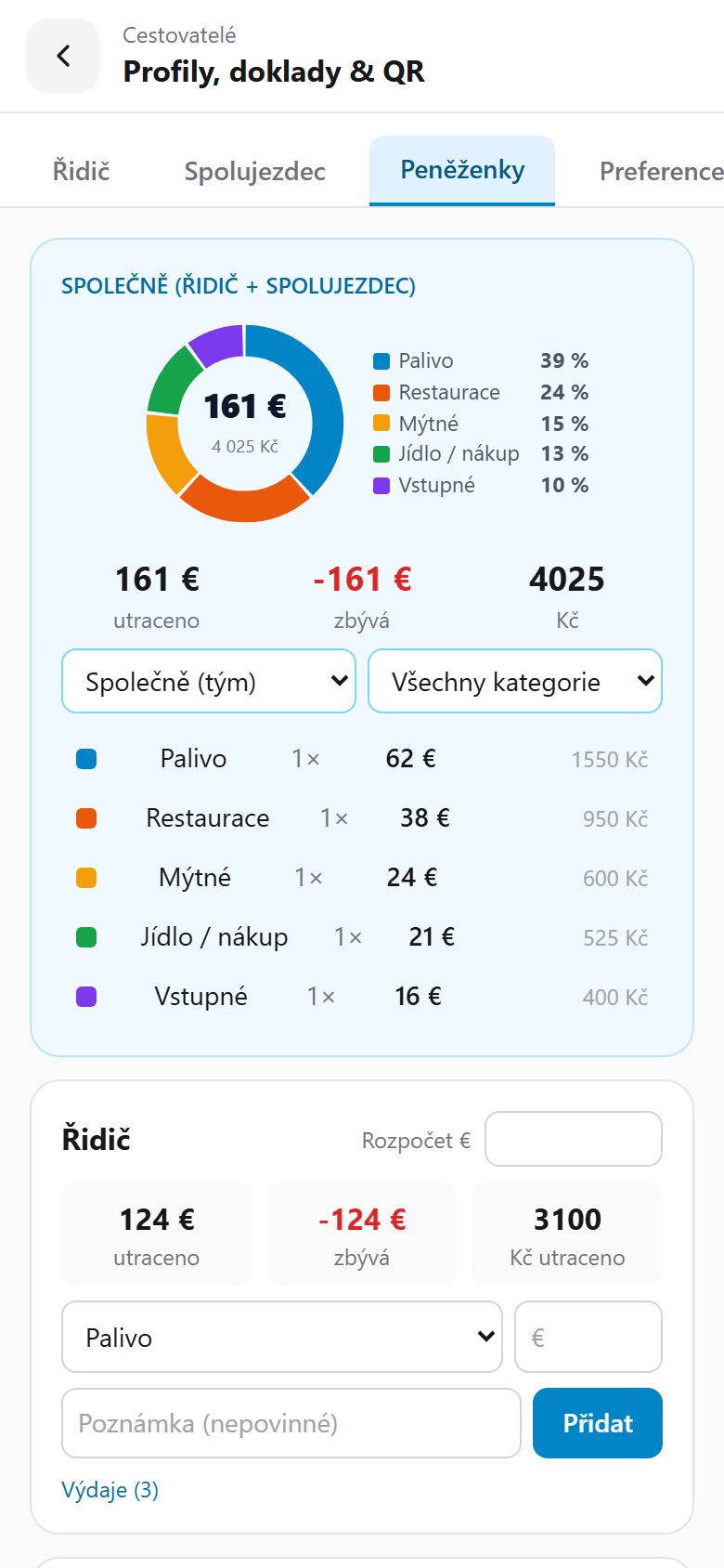
  • Wallet with charts. A colour pie by category, a budget bar (red when overspent), stats by person and category with a link to the map where you paid. Crowns and euros side by side.
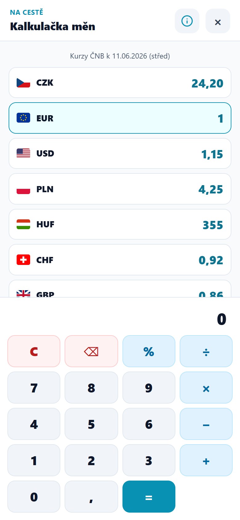
  • Currency calculator with CNB rates. A full calculator + a currency column (CZK, EUR, USD, PLN, HUF, CHF, GBP and the currencies of countries on your route) with live Czech National Bank rates — type an amount in one currency and the rest convert instantly. Works offline too.

How it helps: The little things you'd otherwise juggle across five apps and in your head are in one place — and the app warns you before they become a problem.

Currency calculator with live CNB rates

A calculator and currency converter in one: CZK, EUR, USD, PLN, HUF, CHF, GBP and the currencies of countries on your route, with current Czech National Bank rates.

Type an amount in any currency and the rest convert. Works without signal too.

Currency calculator with CNB rates for CZK, EUR, USD, PLN, HUF, CHF and GBP

Wallet with charts

A colour pie by category, a budget bar and stats for every crew member. Crowns and euros side by side. After you've paid for parking the app asks for the price and logs it for you.

Wallet with a pie chart of spending by category and a budget in euros and crowns

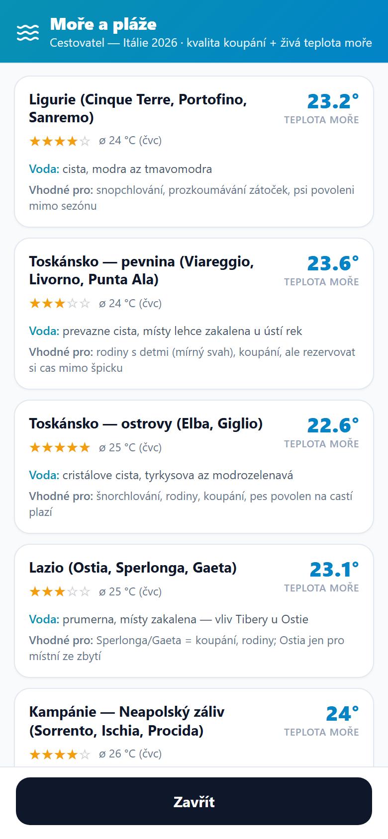
Sea and beaches with water temperature

For coastal regions you see the bathing-quality rating, live sea temperature and who the beach suits — families, snorkelling, or dogs out of season.

You know in advance where the water will be clean and pleasantly warm.

Sea and beaches overview with bathing-quality rating and live sea temperature for Italian regions

Compass with nearest destinations and altitude

The compass shows the nearest destination, town and city in the direction you're heading, plus speed, altitude and GPS accuracy.

Next to it, a spirit level to level the car for sleeping — all in the Tools section.

Compass with nearest destinations in the viewing direction, altitude and GPS accuracy
Safety and healthOfficial weather alerts, storms, heat watch for the dog and expiry reminders.

Alerts and watches

  • All weather under one icon. The "Weather" menu gathers the rain radar, clouds, temperatures (air and sea), wind and alerts in one place — fewer icons on the map, everything together.
  • Rain radar right on the map. An animation of rainfall for the last ~2 hours (in 10-minute steps) plus a short forecast ahead, with the time of each frame and a pause/play button — you see where the storm is moving.
  • Wind layer for surfing and kiting. Arrows show wind direction and strength (m/s, including gusts), the colour hints at strength from light to stormy; a legend sits in the Weather panel. Source Open-Meteo, free.
  • Official weather alerts (MeteoAlarm). Wildfires, floods, avalanches, heatwaves, strong wind for all of the app's countries. Serious alerts arrive as a system notification with sound, even when the phone is in your pocket and the app is closed.
  • Local storm forecast for the next 36 h right where you are.
  • Heat watch for the dog. When it's set to hit 35 °C or more, the assistant reminds you about hot asphalt, shade, water and outings early in the morning.
  • Expiry watch. Insurance, motorway stickers, the MOT, e-shop deadlines — every reminder has a real date and an "Add to calendar" button.

Weather and forecast always at hand

Current weather right where you are, and a 7-day forecast with temperatures and chance of rain. Plus official MeteoAlarm alerts as a notification with sound.

Current weather and a seven-day forecast with temperatures and rainfall

Rain radar right on the map

The Radar (rain) layer plays an animation of rainfall for the last ~2 hours (in 10-minute steps) plus a forecast ahead right on the route map — with the time of each frame and a pause/play button you see where the storm is moving.

No separate weather app — radar, clouds, temperatures, wind and the sea live under one icon, right where you plan.

Route map with the rain radar layer on, showing current rain
Dog and familyDog rules at beaches, dog beaches nearby, kid-friendliness, the "For us" filter.

So the trip suits the whole crew

  • Dog rules at places. At beaches and other spots, whether dogs are allowed (Italian beaches often ban them in summer) — verified at 98% of places for Italy. The "No dog ban" filter hides them in one tap.
  • Dog beaches nearby. Where dogs aren't allowed on the main beach, the app shows the nearest dog beach.
  • Family attractions and kid-friendliness. At hundreds of places (shallow water, pram access, safety) + dozens of attractions (water parks, zoos, safari). Family-friendly places are marked with a green child badge and a "For kids" filter.
  • The assistant factors in children. When you travel with kids, the AI guide takes that into account when picking places and proposing a route.
  • The "For us" filter. Hides everything you can't manage (dog ban + physically demanding). The panel is transparent: it shows what it hid and why, and every criterion can be turned off.
MemoriesQuick stamped photos, AI caption, a journal and a finished travelogue.

They build themselves along the way

  • Quick stamped photo. Shoot full-screen and, based on GPS, the shot is stamped with the country flag, town and region and the date — postcard style only when you want it. Edits available (brightness, contrast, "auto-enhance").
  • AI caption and hashtags from context (where you are, who's travelling, the dog, the car).
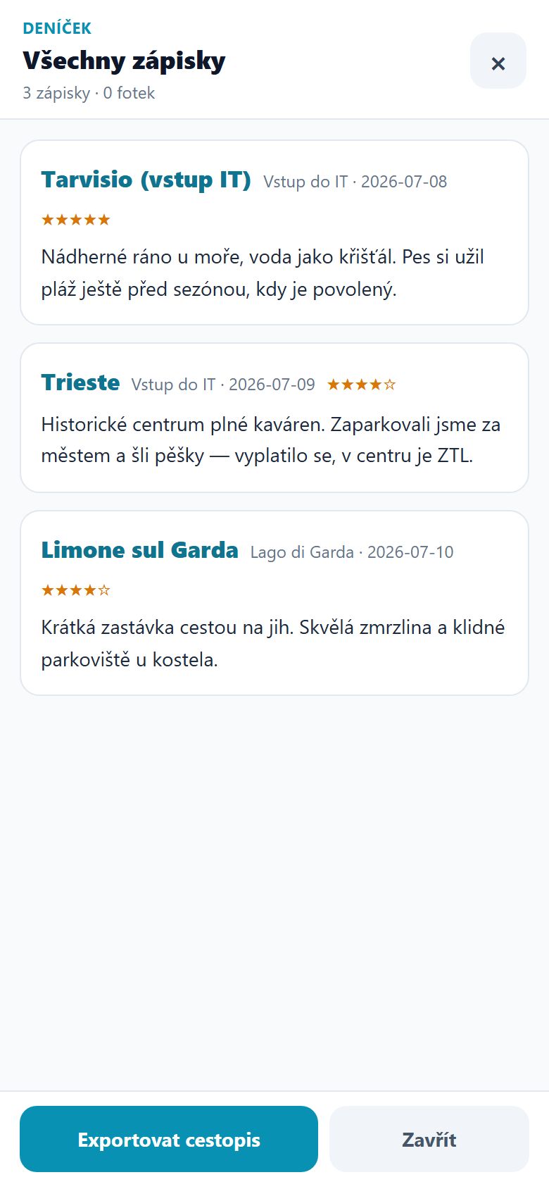
  • Journal. Entries in chronological order, with photos and ratings. The AI can rewrite an entry in different tones (even "funny").
  • Travelogue and backup. From the journal and photos you assemble one nice document (to read, print, PDF). The backup saves a ZIP with photos, journal, GPS track and settings — the app backs up by itself once a week.

How it helps: Memories build themselves (a photo + a few words) and at the end you have a finished travelogue — no assembling an album after you get back.

A journal that becomes a travelogue

A few words a day at each place, with ratings and photos. From the journal the app assembles one nice travelogue to read, print or save as PDF — the AI can also rewrite an entry in a different tone.

Journal with entries from places, ratings and an Export travelogue button
Community and badgesVerify visited places, explorer badges, share a route with family.

You travel, everyone's data improves

  • Verify visited places. The app detects from GPS that you've visited a place and asks whether the opening hours, entry fee and status are right. You help keep the data fresh — the place detail then shows "Verified on site" with a date.
  • Explorer badges. Verifying, rating, journalling and photos earn you points and levels — from Novice to Master Traveller. Your own card in the profile.
  • Community place reports. Run into a closed campsite, a different price or a new barrier? With one button you report the change — you help fellow travellers and the data gets fixed.
  • Tip of the day. The app gradually (at most one a day) shows you an advanced feature you don't know yet — "Show" opens it right away.

Share a route with family

  • Send a finished route as a link (it opens for the recipient right in the app — View or Add to plan), as a day-by-day itinerary to WhatsApp, or as a .json file. No registration, no account.
  • Receiving a shared route. Open the link and you see a preview on the map and a list of places, and add them to your plan in one tap.
Detailed destination guidesCountry guides + a shared "Before you set off", a phrasebook, tolls step by step.

Country guides verified from local sources

  • Shared "Before you set off" guide. A Shared tab with dozens of practical cards for the whole route and the Balkans, independent of country — money and mobile data, health, drinking water, tolls and vignettes, gas (LPG), and a plan B for heat and rain. Each card has prices, opening hours, tips, links to sources and an "On the map" button.
  • Laws and rules — sleeping in the car and where it's legal (Croatia and Greece: a €300–1000 fine outside campsites; Tyrol: a blanket ban, fines up to €5,000), banned weapons, Sunday closures, siesta and quiet hours.
  • Tolls and vignettes step by step — gate lane colours, categories for a taller car, where you pay extra for tunnels (Brenner, Tauern).
  • Dogs — beach rules, returning to the EU (Serbia without titration; Albania requires titration — arrange it 4 weeks ahead!).
  • Emission zones — the German green sticker (buy it online from home in advance for ~€18).
  • Refuelling (Servito vs. Fai da te), toilets and drinking water, customs limits, fines.
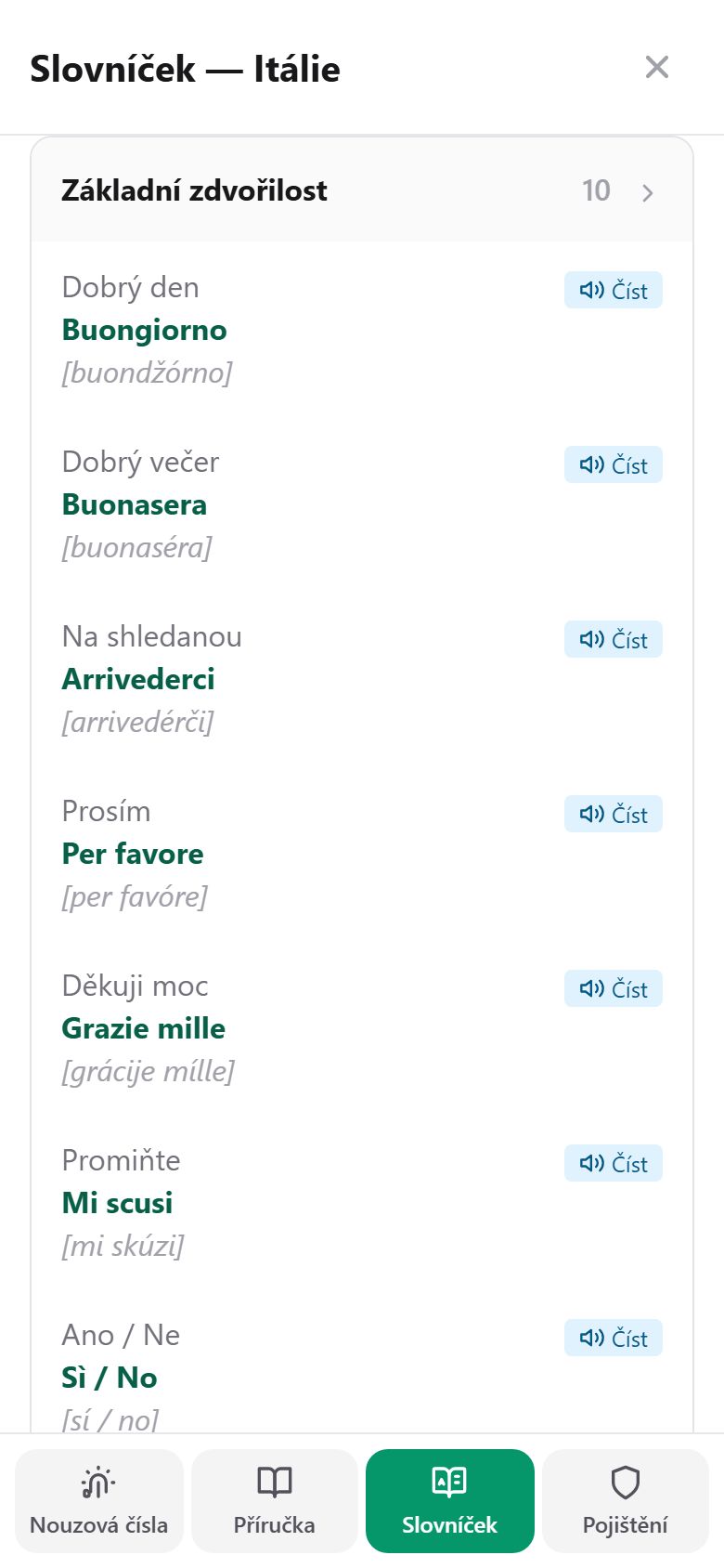
  • Phrasebook — hundreds of phrases (193 in Italian, plus Croatian and others) with pronunciation and a button that reads the phrase aloud in the local language. You can add your own phrases too.
  • Practical place data — campsites and car parks nearby, Google photos and ratings, vets, step-free beaches, sea quality and temperature (8 countries).
  • Campsites with amenity pictograms. At a glance, icons show what a campsite offers — electricity, showers, toilets, water, Wi-Fi, laundry, a rating and a booking contact.
  • You can see freshness. A green strip "AI-verified X days ago" — no guessing whether the entry fee is current.

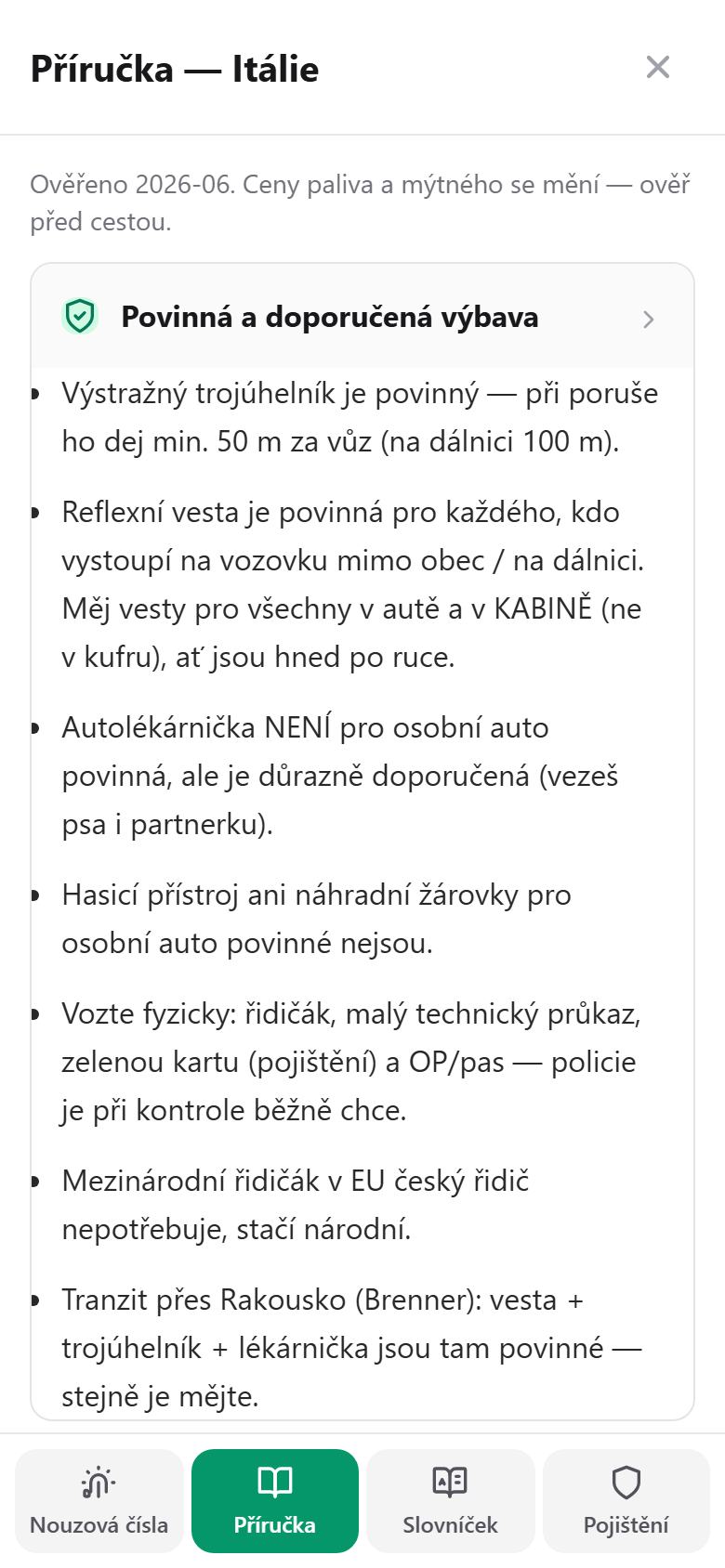
A country guide verified from local sources

Mandatory equipment, documents, sleeping in the car and where it's legal, tolls and vignettes, emission zones, dog rules. With a verification date — you know how fresh the information is.

Guide for Italy — mandatory equipment, documents and rules, with a verification date

Phrasebook with pronunciation

Hundreds of phrases sorted by situation, with pronunciation and a Read button that plays the phrase in the local language. Add your own phrases.

Phrasebook of Italian phrases with pronunciation and a read-aloud button
Offline and privacyWorks without signal, data stays on your phone, no ads.

Works without signal, data stays with you

  • Works without signal. The map library and the data for all countries are in the app — map, plan and guides work even in the mountains. With a button you can also download offline map tiles for an area.
  • Data stays on your phone. Photos, journal, GPS track and profiles live only on your device. No mandatory accounts, family sharing is encrypted, AI is optional.
  • No ads, no data selling. The app is free; an optional voluntary contribution.
  • Built for Czech travellers — 7 interface languages, but written for Czechs: Czech phrases, vignette e-shops, insurers, crowns and euros.
What we're working onSeekBone grows practically every day — more countries, a law watchdog, data freshness.

SeekBone grows practically every day

  • We're deepening more countries. Slovakia (1,048), Poland (764), Hungary (714), Montenegro (656), Slovenia (577), Bosnia (191) already have hundreds of places; Bulgaria, North Macedonia and Turkey are ramping up. The goal: hundreds to thousands of full cards per country, like Italy.
  • Newly started countries. France, Spain, Portugal, Romania and Kosovo already have their first places on the map — we're gradually adding full cards, tolls, priced fuel stations and guides, so a road trip across Europe holds together in one app.
  • Webcams nearby. We're preparing a live-webcam layer on the map (awaiting activation).
  • Permanent data enrichment. Places are collected and verified continuously, plus a nightly re-check of card freshness.
  • Law watchdog. A weekly check for changes (tolls, ZTL, dog rules, emission zones) — whatever changes is reflected in the app.
  • Wiring health databases (SÚKL medicines + ICD-10 diagnoses) into the profile autocompletes.

What specifically we're preparing

We build from your feedback — send your wish right in the app.

Why SeekBone, not paper or Google MapsEverything in one, it counts your money, works offline, your data stays with you.
  • Everything in one. Map, plan, tolls, wallet, SOS, health cards, journal, guides — instead of five apps, one where the parts talk to each other.
  • It counts your money. Real tolls, vignettes, fuel, budget — Google Maps won't tell you a roof box means double the toll.
  • Works offline. Abroad without roaming you won't be left without navigation or a guide.
  • It knows you travel with family and a dog. Dog rules at beaches, kid-friendliness, heat watch, dog QR collar.
  • Ready for an emergency. SOS with a ready message in a foreign language, a health QR for paramedics, weather alerts.
  • Your data stays with you. No accounts, ads or data selling — unlike the big services where you are the product.

We build from your feedback

Got a good idea? Feel something's missing? Different needs from the next traveller?

Send us a suggestion right in the app with the Custom wish button — we'll act on it and an update usually arrives within a day, unless it's something major. The app grows exactly according to what travellers need from it.

In the app: the "Custom wish" button
About usA small Czech team of travellers — why we build SeekBone and how we protect your data.
A small Czech team of travellers. We're a bunch who really roam Europe in a van with a dog — from the Czech mountains to southern Italy. We build SeekBone as people who need this app on the road themselves.
Why we do it. We do it mainly for ourselves — for our own road trips. And because it helps us, we share it on: so others who travel the way we do can benefit too.
Your data stays with you. Everything lives only on your device — no accounts, no tracking, no ads, no data selling. The only thing that leaves is what you choose to share.
All free. The app is and stays free. We'd just be glad if you support us — a voluntary contribution is right there in the app. No pressure, no paid features hidden behind a paywall.
SeekBone adapts to how you travel: at the start you pick Simple, Standard or Full — nothing is deleted, features are just hidden. The app grows with you.

Hit the road with SeekBone

Open the app in your browser, or install it on Android.

No install needed: open the web version.
Coming soon to Google Play; App Store planned.

Share SeekBone with friends

The app is free. The more of us there are, the more accurate its information gets. Help us spread the word.

Link copied